


To Fly--With The Paraglider In Your Backpack
On the road…again!
Afghanistan to Zambia
Chronicles of a Footloose Forester
By Dick Pellek
To Fly A Paraglider From The Rim Of Fogo
This is a wishful thinking story that is part of a dreamer’s bucket list. Yes, it is wishful thinking but it is something that is entirely feasible. Paraglider pilots know that if you have a suitable jumping off point and sufficient altitude, it is possible to glide from a high point to any lower point in your glide path. Of course, that assumes that there are no obstacles in your path and you have calculated the descent ratios properly.
Gliding from the rim of Fogo Volcano in Cape Verde, to the black sand beach beyond and directly over the airstrip on the Island of Fogo can be planned and executed in virtual reality by simply starting at the volcano’s rim at an altitude of appromimately 8450 feet and launching into the wind in a SW direction. For purposes of discussion, the launch azimuth is approximately 230 degrees. The land drops away on all sides, so losing too much altitude too soon is not an issue. When viewed at ground level in a Google Earth photograph, one can see the objective and the airstrip along the flight path. The daydreaming Footloose Forester has made the virtual flight in a Google Earth flight simulator many times, and is confident that a real flight in a real paraglider is not out of the question. Just try it and you will be convinced that flying a real paraglider is not some kind of joke.
To make the exercise more convincing, Footloose Forester suggests that you check the flight plan for yourself, perhaps marking a red line corridor to verify its feasibility. The recommended flight path, as discussed here, goes directly over the airstrip; and is a real convenience in keeping the objective in sight. A safe landing zone is critical; and only by co-incidence is the recommended landing zone directly in-line from the caldera rim and over the runway. A careful search of alternative landing places did not turn up any better landing zone; in fact the width of the beach beyond the airstrip was the only factor that counted. All other beaches were either too narrow, too uneven; or practically non-existent.
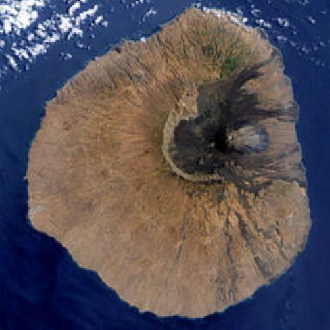
Fogo Volcano in Cape Verde. Launch point is at 8 O'clock position or approximate heading of 230 degrees
The fanciful flight from the rim of a volcano may be wishful thinking, but the person who actually does it someday will know that it really was not as wild as it seemed. The satellite photo above represents the entire island known as Fogo; the large darkened area is the older caldera into which it is possible to drive an automobile; and the ash grey cone at the right center is the active cinder cone known as Pico. Pico last erupted in 1995 and is not under consideration as a launching zone. Instead, the would-be paraglider pilot can hike up the northeast side of the caldera rim along trails that already exist; and only then decide on the exact spot that is best for a foot launch into the wind.

Pico, an active cinder cone within the main caldera of Fogo Volcano
Bits and pieces of the flight plan might not seem to add up, until you see the virtual flight from the rim of the caldera in a Google Earth flight simulator. The beauty of the flight simulator is that it allows you to check the starting (launch) elevation, monitor the progress of the descent, and to verify the descent rate and altitude above the ground as you proceed. Along the way, you will notice that when you glide above the mid-length of the airstrip, you are on the correct azimuth to land on the widest black sand beach of the whole island.
Taking a virtual flight is not merely entertainment. All of the places are real. Modern computer technology makes it possible to confirm most of the ideas presented here. People reading the first draft of this story will note that the azimuths are different from what is given above. That is the beauty of on-line editing; it is possible to make the corrections and re-post the story. By way of example, the Google satellite photo below was added more than three years after the original chronicle was posted.

Launch site checked and double-checked for feasibility
Some people have said that if we can think it, we can do it. Stuffing your paraglider into your backpack is only the beginning of the quest. Oh, by the way, launching off the rim of Mt. Kilimanjaro in Tanzania with a paraglider should be a piece of cake. Dreamers the world over will rejoice when that actually happens, but wonder why it didn't happen sooner.
